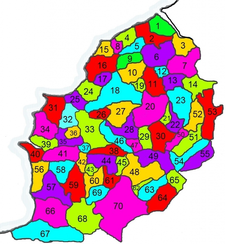
Below is a map of the general area that we cover as a Society, showing the parishes that are known to have existed in 1832. This roughly equates to the same area that forms North Somerset District Council's boundaries, plus that covered by the Axbridge Registration District which was setup in 1837.

1. Easton in Gordano 5. Clapton in Gordano 9. Tickenham 13. Barrow Gurney 17. Kenn 21. Butcombe 25. Wick St Lawrence 29. Burrington 33. Banwell 37. Christon 41. Bleadon 45. Axbridge 49. Charterhouse 53. Chew Magna 57. Brent Knoll 61. Weare 65. Priddy 69. Chapel Allerton
| 2. Portbury 6. Wraxall 10. Nailsea 14. Dundry 18. Yatton 22. Nempnet Thrubwell 26. Puxton 30. Blagdon 34. Weston-super-Mare 38. Winscombe 42. Loxton 46. Shipham 50. Ubley 54. West Harptree 58. Lympsham 62. Nyland 66. Burnham on Sea 70. Wedmore
| 3. Abbots Leigh 7. Long Ashton 11. Backwell 15. Walton in Gordano 19. Brockley 23. Winford 27. Congresbury 31. Kewstoke 35. Hutton 39. Uphill 43. Biddisham 47. Rowberrow 51. Compton Martin 55. East Harptree 59. East Brent 63. Rodney Stoke 67. Huntspill
| 4. Portishead 8. Weston in Gordano 12. Flax Bourton 16. Clevedon 20. Wrington 24. Kingston Seymour 28. Churchill 32. Worle 36. Locking 40. Brean 44. Compton Bishop 48. Cheddar 52. Chew Stoke 56. Berrow 60. Badgworth 64. Westbury 68. Mark
|
Due to population movement and concentration on places such as Weston-super-Mare, Clevedon and Nailsea, some of the above parishes were subsequently split to form new parishes.
The following parishes were split as follows:
- Clevedon into All Saints; Christ Church & St Andrew.
- Huntspill into St Peter & All Hallows (West Huntspill), and All Saints (East Huntspill).
- Nailsea into Christ Church & Holy Trinity.
- Weston-super-Mare into All Saints; Christ Church; Emmanuel; Good Shepherd; Holy Trinity; St John; St Paul & St Saviour.
We are working towards producing parish transcripts for all parishes in our area. And we have also transcribed records for a number of parishes adjoining us, such as Clutton and Weare.


